PA ballast Question 17

17. A small, three-story rectangular office building in a temperate climatic region is planned for the site shown. To simplify grading, the long dimension of the building will be placed parallel to the contour lines.
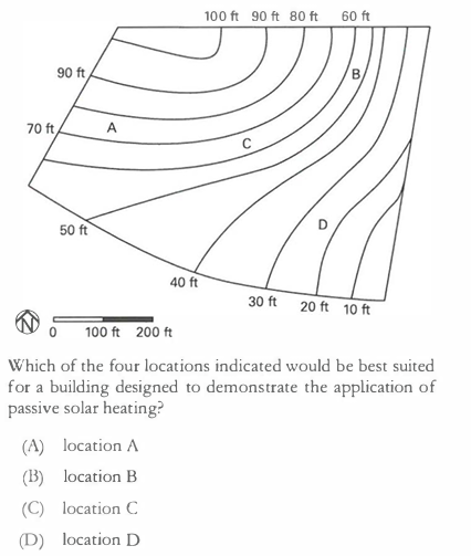 Can anyone explain why is it not A, as it faces south more directly than C, which is the correct answer by the book.
-

Hello,
I think if you analyze this more closely, you will see that C is the correct answer. Buildings in a temperate climate are supposed to face south, but slightly SE by 5-25 degrees. Location A actually would face south, slightly WEST. If you draw a rectangle perpendicular to the contours at A, it becomes clear.
Hope this helps!
Keep studying,
Rebekka
-

Architect_inprocess
Rebekka's spot on. As to why - you can describe it as a sequence-of-returns thing. In a temperate climate, for optimum passive solar heating per the question, you want heat from direct solar gains in the morning to warm up your building after the slightly-too-cold night. You don't want solar gains at the end of the day from the west after you've already warmed up more than you want from the midday sun - thus, the absolute optimum orientation faces slightly east of due south.
Is A a lot worse than C? Not necessarily given the available info in the question - either is much better than B or D who both face far too east-west. C is more central to the lot and has a slightly longer buildable area within the lot along the contour, but also more importantly for the question as-written faces slightly east of south (instead of very slightly west of south as A does). I'd recommend playing around with the Society of Building Science Educators' Climate Consultant app if that isn't quite yet intuitive to you. It's also a great tool for passive design for your career!
Best,
Ralph, the Amber Book Team -
The south, slightly east, exposure also means your building will capture more sunlight in winter, when we need it most, and earlier in the day! Sunrise in winter is in the east, but southeast.
Google “Andrew Marsh sun angle” and create your own 2 or 3D charts. Enter coordinates in Alaska, where you live, and Costa Rica. Plug in winter and summer dates. And compare.
Hope this helps!
RebekkaStep Up ARE
-
Welcome! Ditto to Andrew Marsh's website - I see a lot of candidates from very northern locales and places closer to the equator (Fairbanks and Miami, for example) who struggle with those kinds of sun location/shading questions on the ARE - because the sun is in very different places throughout the year in the temperate latitudes of the US that tend to be tested on the exam when compared to what you're used to!
Best,
Ralph, the Amber Book Team -
Welcome! Ditto to Andrew Marsh's website - I see a lot of candidates from very northern locales and places closer to the equator (Fairbanks and Miami, for example) who struggle with those kinds of sun location/shading questions on the ARE - because the sun is in very different places throughout the year in the temperate latitudes of the US that tend to be tested on the exam when compared to what you're used to!
Best,
Ralph, the Amber Book Team
Please sign in to leave a comment.
Comments
7 comments